Looking for design inspiration? Browse our curated collections!


The watermark at the lower right corner of the image will not appear on the final product.

by Paul Fearn
$28.00
Design Location
Color
Image Size
Product Details
Our Bella / Canvas t-shirts are made from a 50% cotton / 50% polyester blend and are available in five different sizes. All t-shirts are machine washable.
Design Details
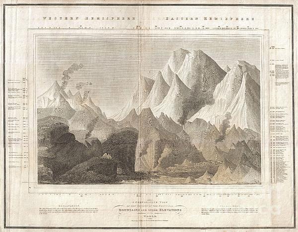
This is one of the earliest and most interesting takes on the comparative heights of principal mountains theme. Comparative mountains charts first... more
Ships Within
1 - 2 business days
Average Rating (4.34 Stars):


Dana Frederickson
April 27th, 2024

This is an excellent t-shirt! An excellent view of a United Express Embraer-145! Excellent photography and artwork!
Julie Barden
April 27th, 2024

The fit was great. The material was soft, so comfy.
Ka Mei Chan
April 27th, 2024

I ordered the T-shirt in white but finally I got a T-shirt that is light grey. It is not white at all. I am a bit disappointed about it.
Sherrie Yarbro
April 26th, 2024

We loved the T- shirt but needed the print for a cover for my husbands prosthetic leg. He was in an awful accident a year and lost a leg as a result. He is a Beatle Fanatic and we had to put them on his new leg. Thanks for the awesome art and it was the perfect size.
Suzanne Hale
April 19th, 2024

Very original shirt, lots of compliments- great fit.
Dana Frederickson
April 19th, 2024

This is an excellent t-shirt! An excellent view of an SAS Connect Airbus A320-251N coming in for a landing! I especially wanted to buy this t-shirt because I am of Swedish descent! Excellent photography and artwork!
This is one of the earliest and most interesting takes on the comparative heights of principal mountains theme. Comparative mountains charts first appeared in the late 18th and early 19th century. Initially these charts focused on Europe or even signal countries, but by the early 19th century the explorations of the world's great peaks had reached a point where such a chart could be composed on a global level. John Thompson, the preeminent Scottish cartographer of the period, introduced this chart, one of the first and most interesting of the genre. Covering both the eastern and western hemispheres, this chart shows not only the heights of mountains, but also compares them to important buildings, cities, vegetation limits, and even fauna. Thompson divides his map in to the western hemisphere, on the left, and the eastern hemisphere on the right. In the Western Hemisphere, he identifies the Ecuadorian peak of Chimborazo at the highest mountains - the great Chilean peaks had not yet been...
My passion is Photography and Aviation or is that Aviation and Photography ! I hope you enjoy my photographs.

Our return policy is very simple:
If you're not happy with a purchase that you made on FineArtAmerica.com, for any reason, you can return it to us within 30 days of the order date. As soon as it arrives, we'll issue a full refund for the entire purchase price. Please note - Fine Art America does not reimburse the outgoing or return shipping charges unless the return is due to a defect in quality.
Fine Art America sells thousands of pieces of artwork each month - all with a 100% money-back guarantee. We take great pride in the fact that hundreds of thousands of artists have chosen Fine Art America to fulfill their orders, and we look forward to helping you select your next piece!
All t-shirts ship from our production facility within 1 - 2 business days of your order.
$28.00


There are no comments for 1817 Thomson Map of the Comparative Heights of the Worlds Great Mountains. Click here to post the first comment.